#KUFieldWorks: Studying the impact of rapid urbanization on water quality in Johnson County
Editor’s note: Fieldwork provides invaluable insights about real-world environments and processes, expanding and reinforcing what researchers learn in classrooms, labs and collections. KU faculty, staff and students across a spectrum of disciplines are taking their inquiry directly to rivers, prairies, dig sites, glaciers, islands, burial grounds and more this summer. Through the #KUFieldWorks series, we'll join them on their adventures.
Q&A with civil, environmental and architectural engineering assistant professor Admin Husic
Johnson County is growing rapidly — and urbanizing to meet that growth. Admin Husic, civil, environmental and architectural engineering assistant professor, and his KU Ecohydraulics Lab are conducting field research in seven streams in the northeast Kansas county to better understand urbanization’s impact on water quality.
While the global urban population continues to expand, the impact on water quality of converting natural and rural landscapes into urban zones is still a bit of a mystery. Expansive urbanization will have consequences to water access and security — and the lab’s research aims to understand how to create sustainable water resources.
The Kansas Water Resources Institute, the Kansas National Science Foundation EPSCoR program, and the Johnson County Stormwater Management Program fund the lab’s various projects in Johnson County.
What methods, approaches, experiments did you use to answer your research question?
My students and I use a variety of methods, most prominently high-frequency aquatic sensors and radioisotope sediment tracers.
The aquatic sensors relay minute-by-minute information of river water quality, which we can access remotely, regarding the water temperature, oxygen levels, nutrient concentrations, turbidity and organic matter levels. In the past, you would physically drive to a location, take a sample, bring it back to the lab, and analyze the results, which could take several days. With remote sensors, we get thousands of instantaneous data points in the same amount of time, helping us make better decisions. Also, a lot of the most interesting stream behavior happens during storms, which are short-lived, so traditional sampling might miss their occurrence. Storms can also be dangerous to physically sample, so these aquatic sensors give us informative data that would otherwise be challenging to collect.
The radioisotope sediment tracers, particularly plutonium, help us answer where sediment flowing in a river comes from. With that knowledge, we know where we need to focus our efforts on reducing sediment loading to streams, which can have negative effects, such as smothering fish habitats, transporting heavy metals and clogging treatment intakes. Radioisotopes were introduced in large quantities into the atmosphere during nuclear weapons testing in the 1950s and 60s. Over time, these radioisotopes deposit to the soil surface where they become concentrated. Because they are only present on the surface and not deeper in the soil, you can use this information to identify where river sediment originates from above or below the land surface.

Why does your study matter to your field or to society?
The projected increase in global urbanization will have consequences to clean water access and security, and it’s important to understand that so we can create sustainable water resources. If we can identify how humans impact the environment in negative ways, we can scale back those negative activities, be proactive in future efforts, and identify remediation strategies.
What are some memorable (funny, scary, surprising) moments from the field?
One of the risks of leaving our sensors in the river for months is that storms throw everything at them, including trees and tires. Several sensors have been ripped from their secured steel cables, which is terrifying as the sensors are quite expensive. However, we’ve been fortunate to recover them every time! Plus, they continue to function afterward, highlighting how robust these sensors have become.
When is fieldwork frustrating, challenging or overwhelming?
How frustrated I am about fieldwork is a function of how hot it is outside. Wearing neoprene waders for hours at a time in 90-degree weather is not fun — but the data collected makes it all worth it.
How does fieldwork complement the work you do elsewhere?
The data we generate from fieldwork goes into computational numerical models that we develop on campus. We use these models to try and infer processes that we cannot directly measure or extrapolate our measurements into future predictions. Doing this requires a lot of computing power, so our group works with the KU Center for Research Computing where we use high-performance computing to run models that would otherwise take years on a single machine.
What do you enjoy most about being in the field?
One of the great things about studying engineering is that it opens your eyes to the fact that nature is basically a differential equation solving itself in real time. To get a true appreciation for all of the variables in that equation, it helps to go out and see it for yourself. Being in the field is inspiring and helps me see problems in a new way and sparks my imagination.
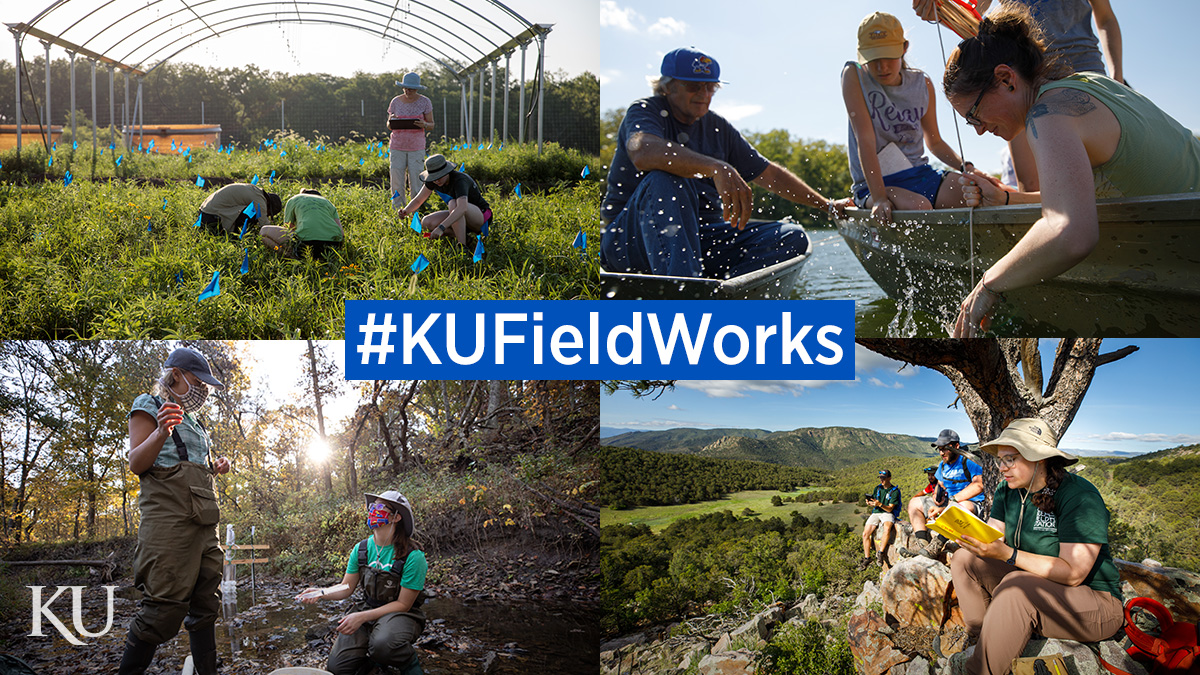
Top photo: University of Kansas researchers conduct fieldwork in prairies, rivers, streams and mountains. The #KUFieldWorks series follows researchers on their fieldwork adventures.
Second photo: Admin Husic, civil, environmental and architectural engineering assistant professor, examines a stream to find a good place to put a sediment sampler.
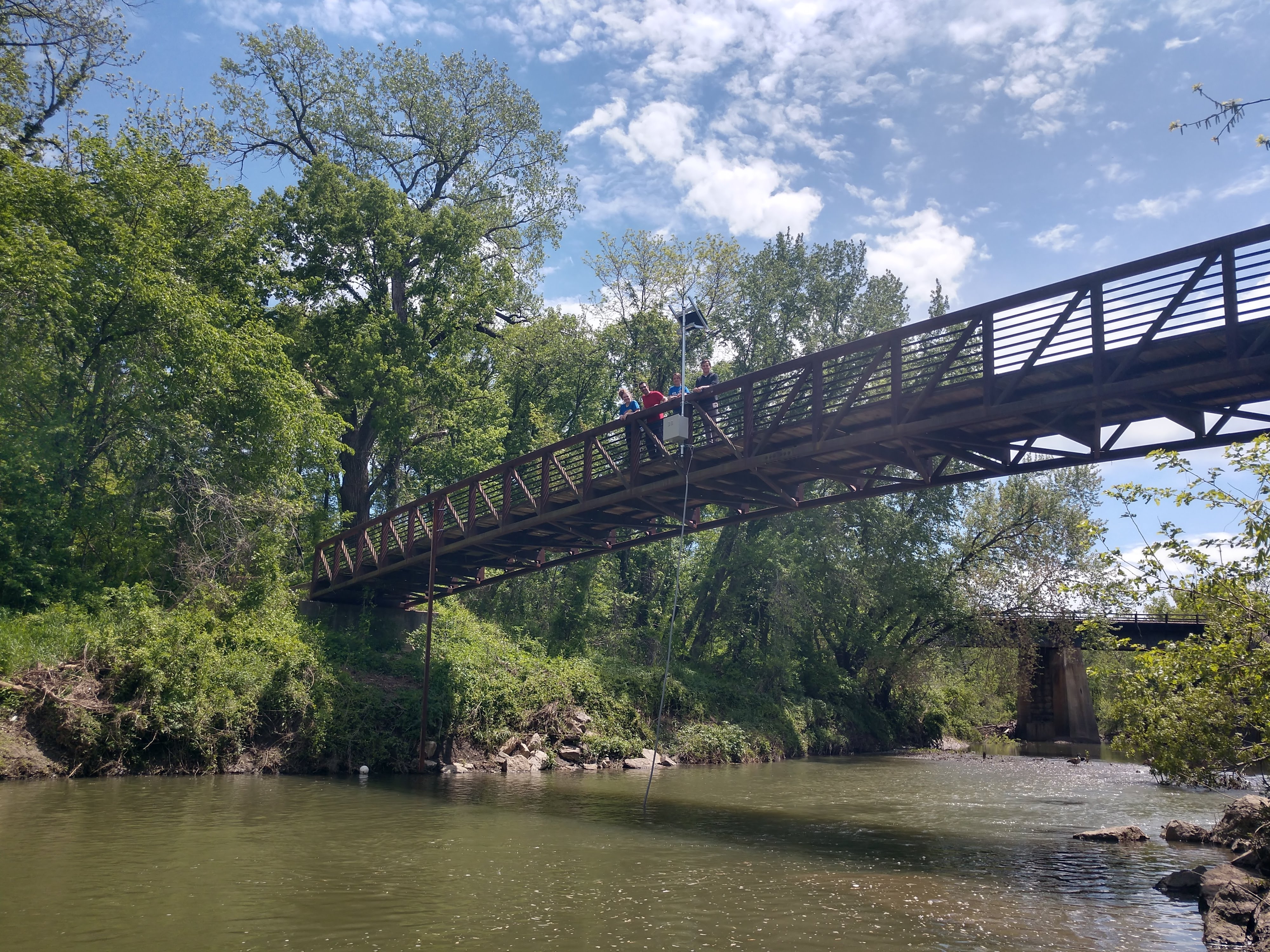
Third photo: Ecohydaulics lab students, including Savannah Smith, Amirreza Zarnaghsh, Alexandra Depew and Logan Wilson, celebrate the first high-frequency sensor installation, powered by solar and suspended from a trail bridge into Mill Creek below.